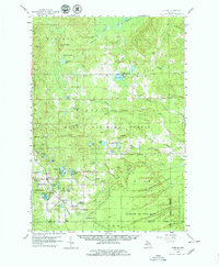
1959 Map of Glennie
USGS Topo · Published 1979About this map
Barton City and Glennie anchor this late 1950s survey of the northern lake country, where rural life revolves around the Huron National Forest. The landscape is a network of small glacial lakes such as Jewell Lake, Sprinkler Lake, and Curtis Lake, interspersed with active sandpits and gravel pits that reflect the region's local geology. Local history and genealogy interests are well-represented by the Glennie Cem and several community landmarks, including Maple Ridge Sch and the Lott Ch near the southern border.
Find a feature on this map
69 named features on this map. Tap any name to fly to it.
Don’t see what you’re looking for? This feature index may not catch every label — zoom into the map to look around manually.
Map Details
Editions of this 1959 Glennie Map
3 editions found
Other maps of this area

1954 · Tawas City
USGS Topo · 1:250,000

1958 · Tawas City
USGS Topo · 1:250,000

1959 · Tawas City
USGS Topo · 1:62,500

1959 · East Tawas
USGS Topo · 1:62,500

1959 · Glennie
USGS Topo · 1:62,500

1959 · Harrisville
USGS Topo · 1:62,500

1968 · Hale
USGS Topo · 1:24,000

1971 · Spruce
USGS Topo · 1:24,000

1972 · Hubbard Lake
USGS Topo · 1:24,000

1972 · Curran
USGS Topo · 1:24,000