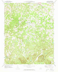
1970 Map of Glenola
USGS Topo · Published 1973About this map
Glenola and the surrounding rural communities of Randolph County are captured here in a period of transition during the late 1960s. The landscape is defined by the drainage basins of the Uwharrie River and Caraway Creek, where small settlements like Edgar, Hillsville, and New Market are linked by a network of local roads and the Southern railway line. The map highlights the high density of community centers, including Poplar Ridge Ch, Marlboro Ch, and Liberty Grove Ch, many of which served as the anchor for these dispersed rural neighborhoods for generations.
Find a feature on this map
35 named features on this map. Tap any name to fly to it.
Don’t see what you’re looking for? This feature index may not catch every label — zoom into the map to look around manually.
Map Details
Editions of this 1970 Glenola Map
2 editions found
Other maps of this area

1949 · High Point West
USGS Topo · 1:24,000

1950 · High Point East
USGS Topo · 1:24,000

1951 · High Point East
USGS Topo · 1:24,000

1951 · Fair Grove
USGS Topo · 1:24,000

1953 · Raleigh
USGS Topo · 1:250,000

1953 · Charlotte
USGS Topo · 1:250,000

1954 · Charlotte
USGS Topo · 1:250,000

1954 · Raleigh
USGS Topo · 1:250,000

1957 · Denton
USGS Topo · 1:62,500

1957 · Asheboro
USGS Topo · 1:62,500