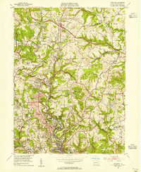
1953 Map of Glenshaw
USGS Topo · Published 1955About this map
Industrial activity and community expansion define this early 1950s landscape north of Pittsburgh. Along the Baltimore and Ohio rail corridor, the towns of Glenshaw and Allison Park serve as central hubs for the surrounding hills of Hampton and Shaler townships. The economy of the era is anchored by large-scale extraction, evidenced by the Wildwood Mine and the Dorseyville Portal Harmar Mine, while the newly constructed Pennsylvania Turnpike cuts across the northern reaches, complete with the Butler Valley Interchange Toll House.
Find a feature on this map
71 named features on this map. Tap any name to fly to it.
Don’t see what you’re looking for? This feature index may not catch every label — zoom into the map to look around manually.
Map Details
Editions of this 1953 Glenshaw Map
This is the sole edition of this map. No revisions or reprints were ever made.
Other maps of this area

1904 · Mc Keesport
USGS Topo · 1:62,500

1904 · Carnegie
USGS Topo · 1:62,500

1906 · Carnegie
USGS Topo · 1:62,500

1906 · Sewickley
USGS Topo · 1:62,500

1907 · Pittsburg
USGS Topo · 1:62,500

1908 · Sewickley
USGS Topo · 1:62,500

1908 · Carnegie
USGS Topo · 1:62,500

1908 · New Kensington
USGS Topo · 1:62,500

1910 · New Kensington
USGS Topo · 1:62,500

1948 · Pittsburgh West
USGS Topo · 1:24,000