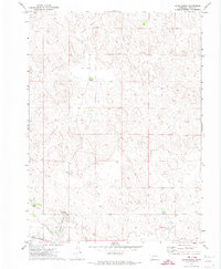
1971 Map of Glinn Ranch
USGS Topo · Published 1974About this map
Glinn Ranch and Drucker Ranch sit within the cattle country of Keith County in the early 1970s. This survey, conducted via aerial photography in 1970, depicts the characteristic sandhills topography and ranching infrastructure of western Nebraska. In the southern portion of the sheet, the Union Pacific railroad tracks cut across the landscape, marking a vital transportation artery through the High Plains. Drainage patterns are defined by the seasonal flow of Spring Creek and the sweeping depression of Mannon Valley to the north. The map provides a detailed view of the section lines and fences that partitioned the open range during this era, illustrating the distribution of isolated ranching headquarters in a sparsely populated region of the Nebraska panhandle.
Find a feature on this map
7 named features on this map. Tap any name to fly to it.
Don’t see what you’re looking for? This feature index may not catch every label — zoom into the map to look around manually.
Map Details
Editions of this 1971 Glinn Ranch Map
This is the sole edition of this map. No revisions or reprints were ever made.
Other maps of this area

1897 · Ogallala
USGS Topo · 1:125,000

1898 · Paxton
USGS Topo · 1:125,000

1900 · Ogallala
USGS Topo · 1:125,000

1901 · Paxton
USGS Topo · 1:125,000

1954 · North Platte
USGS Topo · 1:250,000

1956 · North Platte
USGS Topo · 1:250,000

1957 · North Platte
USGS Topo · 1:250,000

1967 · North Platte
USGS Topo · 1:250,000

1971 · Martin
USGS Topo · 1:24,000
1971 · Packard Ranch
USGS Topo · 1:24,000