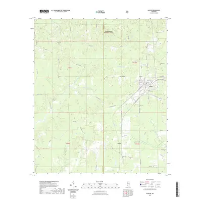
2021 Map of Gloster
USGS Topo · Published 2021About this map
Gloster stands as the primary hub in this southwest Mississippi survey, situated along the county line where Wilkinson Co meets Amite Co. The landscape is defined by the winding paths of the Buffalo River and Little Buffalo River, which carve through the dense timberlands of the Homochitto National Forest. The map reveals a dense network of family and community history, evidenced by over a dozen documented burial sites including Roseland Cem, Gloster Woodlawn Cem, and Galilee Cem. Southeast of the main town, the settlement of Tatum sits near the headwaters of Tatum Cr, illustrating the typical rural development patterns of the region. The presence of numerous named local roads, such as Macedonia Rd and Bennie Cassells, provides specific navigational context for researchers tracing early 21st-century property boundaries and rural access routes within the forest and surrounding parishes.
Find a feature on this map
81 named features on this map. Tap any name to fly to it.
Don’t see what you’re looking for? This feature index may not catch every label — zoom into the map to look around manually.
Map Details
Editions of this 2021 Gloster Map
This is the sole edition of this map. No revisions or reprints were ever made.
Other maps of this area

1953 · Natchez
USGS Topo · 1:250,000

1956 · Natchez
USGS Topo · 1:250,000

1959 · Natchez
USGS Topo · 1:250,000

1961 · Liberty
USGS Topo · 1:62,500

1961 · Crosby
USGS Topo · 1:62,500

1961 · Gloster
USGS Topo · 1:62,500

1962 · Bude
USGS Topo · 1:62,500

1984 · McComb
USGS Topo · 1:100,000

1984 · Woodville
USGS Topo · 1:100,000
1988 · Homochitto
USGS Topo · 1:24,000