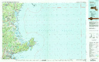
1984 Map of Gloucester
USGS Topo · Published 1984About this map
The rocky coastline of Cape Ann and the expansive marshes of the North Shore dominate this mid-1980s landscape. From the busy industrial and maritime centers of Salem and Beverly to the educational corridors housing Salem State College and Endicott College, the map illustrates a region balanced between urban growth and significant conservation efforts. The massive barrier system of Plum Island State Park and the Parker River National Wildlife Refuge provides a striking contrast to the developed harbor towns, protecting a delicate shoreline that has defined the local economy for centuries.
Find a feature on this map
139 named features on this map. Tap any name to fly to it.
Don’t see what you’re looking for? This feature index may not catch every label — zoom into the map to look around manually.
Map Details
Editions of this 1984 Gloucester Map
This is the sole edition of this map. No revisions or reprints were ever made.
Other maps of this area

1886 · Gloucester
USGS Topo · 1:62,500

1886 · Lawrence
USGS Topo · 1:62,500

1888 · Newburyport
USGS Topo · 1:62,500

1888 · Haverhill
USGS Topo · 1:62,500

1888 · Gloucester
USGS Topo · 1:62,500

1888 · Lawrence
USGS Topo · 1:62,500

1888 · Salem
USGS Topo · 1:62,500

1890 · Haverhill
USGS Topo · 1:62,500

1890 · Newburyport
USGS Topo · 1:62,500

1892 · Boston Bay
USGS Topo · 1:62,500