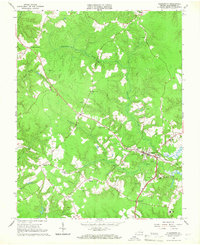
1965 Map of Gloucester
USGS Topo · Published 1967About this map
Gloucester County's landscape in the mid-1960s was defined by its intricate network of wooded bottomlands and quiet rural crossroads. The settlement of Gloucester serves as a central hub, surrounded by smaller communities such as Belroi, Ark, and Sassafras. The terrain is significantly shaped by the presence of large swamp systems, including Woods Mill Swamp, Beaverdam Swamp, and Beech Swamp, which separate the higher ground where historic congregations established landmarks like Zion Poplars Ch, Shepherdsville Ch, and Zion Hill Ch.
Find a feature on this map
48 named features on this map. Tap any name to fly to it.
Don’t see what you’re looking for? This feature index may not catch every label — zoom into the map to look around manually.
Map Details
Editions of this 1965 Gloucester Map
4 editions found
Other maps of this area

1906 · Williamsburg
USGS Topo · 1:62,500

1916 · Kilmarnock
USGS Topo · 1:48,000

1916 · Mathews
USGS Topo · 1:62,500

1917 · Urbanna
USGS Topo · 1:62,500

1917 · Kilmarnock
USGS Topo · 1:62,500

1917 · Mathews
USGS Topo · 1:62,500

1942 · Kilmarnock
USGS Topo · 1:62,500

1943 · Richmond
USGS Topo · 1:250,000

1948 · Ware Neck
USGS Topo · 1:24,000

1948 · Achilles
USGS Topo · 1:24,000