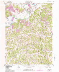
1962 Map of Gnadenhutten
USGS Topo · Published 1985About this map
Gnadenhutten and the surrounding river valley are captured here in a period of transition, documented by surveys in the early 1960s and updated via 1980s aerial photography. The Tuscarawas River defines the local geography, paralleled by the Conrail line and punctuated by the Gnadenhutten Monument (Cemetery), marking the site of the 1782 massacre. To the west, the tiny settlement of Seventeen sits near its namesake Seventeen Cem, while the rugged uplands are dotted with rural landmarks like Kennedy Ch and Rush Sch. The map reveals the heavy footprint of energy extraction and transport in the region, noting numerous gas wells and a Strip Mine in the northwest. Local life is anchored by family-named landscape features like Murphy Hollow and Watson, along with several country churches including West Union Ch and Canaan Hill Ch.
Find a feature on this map
38 named features on this map. Tap any name to fly to it.
Don’t see what you’re looking for? This feature index may not catch every label — zoom into the map to look around manually.
Map Details
Editions of this 1962 Gnadenhutten Map
4 editions found
Other maps of this area

1909 · Antrim
USGS Topo · 1:48,000

1909 · Uhrichsville
USGS Topo · 1:62,500

1909 · Cambridge
USGS Topo · 1:62,500

1911 · Antrim
USGS Topo · 1:62,500

1911 · Uhrichsville
USGS Topo · 1:62,500

1911 · Newcomerstown
USGS Topo · 1:62,500

1912 · Cambridge
USGS Topo · 1:62,500

1913 · Newcomerstown
USGS Topo · 1:62,500

1943 · Newcomerstown
USGS Topo · 1:62,500

1951 · Canton
USGS Topo · 1:250,000