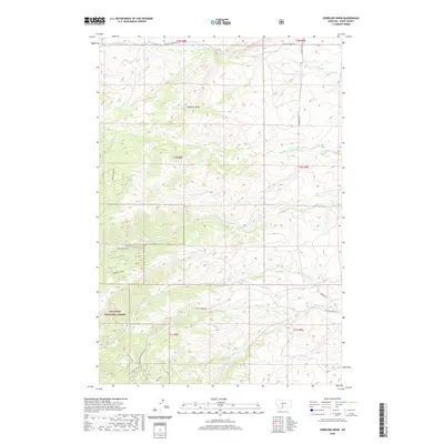
2020 Map of Gobblers Knob
USGS Topo · Published 2020About this map
Gallatin National Forest dominates the southern half of this landscape, where the headwaters of the Willow Creek system converge. The topography is defined by the high point of Gobblers Knob and the surrounding drainage basins of Brackett Cr and Canyon Cr. A network of specialized forest access routes, such as the Bangtail Creek-Connector and trails like Shoe Horn and Taps, suggests a landscape managed for both resource protection and recreation. The mapping of the Middle Fork Willow Cr and S Fork Willow Cr provides a precise view of the hydrology feeding into the larger Willow Creek valley, while the northern sections show the transition from steep timberland to the more open ranching corridors along Brackett Creek Rd.
Find a feature on this map
30 named features on this map. Tap any name to fly to it.
Don’t see what you’re looking for? This feature index may not catch every label — zoom into the map to look around manually.
Map Details
Editions of this 2020 Gobblers Knob Map
This is the sole edition of this map. No revisions or reprints were ever made.
Other maps of this area

1891 · Livingston
USGS Topo · 1:250,000

1893 · Livingston
USGS Topo · 1:250,000

1947 · Bozeman
USGS Topo · 1:250,000

1948 · Bozeman
USGS Topo · 1:250,000

1951 · Bozeman Pass
USGS Topo · 1:62,500

1951 · Gobblers Knob
USGS Topo · 1:24,000

1951 · Clyde Park
USGS Topo · 1:24,000

1951 · Chadborn
USGS Topo · 1:24,000

1951 · Hoppers
USGS Topo · 1:24,000
1951 · Wilsall
USGS Topo · 1:24,000