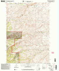
2000 Map of Gobblers Knob
USGS Topo · Published 2005About this map
Gobblers Knob rises as a central landmark in this high-altitude landscape of Park County, where the Gallatin National Forest transitions into a series of established family livestock operations. The map documents a rugged drainage network defined by Brackett Creek and the various forks of Willow Creek, punctuated by legacy homesteads such as Hansen Ranch, Ward Ranch, and Willow Creek Ranch. Small-scale resource extraction is evident near Canyon Creek, where isolated mines and a flume appear alongside forest management infrastructure like the Bangtail Divide Trail. The presence of the Lazy Sheep Camp further illustrates the era's continued reliance on the high pastures of the Bangtail Mountains for seasonal grazing.
Find a feature on this map
24 named features on this map. Tap any name to fly to it.
Don’t see what you’re looking for? This feature index may not catch every label — zoom into the map to look around manually.
Map Details
Editions of this 2000 Gobblers Knob Map
This is the sole edition of this map. No revisions or reprints were ever made.
Other maps of this area

1891 · Livingston
USGS Topo · 1:250,000

1893 · Livingston
USGS Topo · 1:250,000

1947 · Bozeman
USGS Topo · 1:250,000

1948 · Bozeman
USGS Topo · 1:250,000

1951 · Bozeman Pass
USGS Topo · 1:62,500

1951 · Gobblers Knob
USGS Topo · 1:24,000

1951 · Clyde Park
USGS Topo · 1:24,000

1951 · Chadborn
USGS Topo · 1:24,000

1951 · Hoppers
USGS Topo · 1:24,000
1951 · Wilsall
USGS Topo · 1:24,000