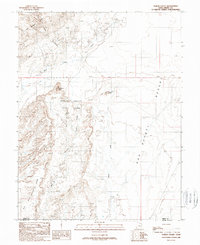
1988 Map of Goblin Valley
USGS Topo · Published 1988About this map
Goblin Valley State Park dominates this 1988 provisional survey, capturing the complex geological formations of the San Rafael Swell at the border of Emery and Wayne Counties. The topography is defined by the sharp verticality of the San Rafael Reef to the north and the expansive San Rafael Desert to the east. Within the valley itself, the map identifies the distinctive hoodoos and rock structures that gave rise to names like Mollys Castle and Wild Horse Butte.
Find a feature on this map
14 named features on this map. Tap any name to fly to it.
Don’t see what you’re looking for? This feature index may not catch every label — zoom into the map to look around manually.
Map Details
Editions of this 1988 Goblin Valley Map
2 editions found
Other maps of this area

1885 · San Rafael
USGS Topo · 1:250,000

1952 · Wild Horse
USGS Topo · 1:62,500

1953 · Temple Mtn
USGS Topo · 1:62,500

1954 · Stinking Springs Creek 4 SW
USGS Topo · 1:24,000

1954 · Stinking Spring Creek 3 SE
USGS Topo · 1:24,000

1954 · Stinking Spring Creek 4 NE
USGS Topo · 1:24,000

1954 · Stinking Spring Creek 4 NW
USGS Topo · 1:24,000

1954 · Stinking Spring Creek 4 SE
USGS Topo · 1:24,000
1954 · Stinking Spring Creek 3 NE
USGS Topo · 1:24,000

1954 · Mt. Ellen 1 NW
USGS Topo · 1:24,000