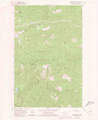
1964 Map of Goddards Peak
USGS Topo · Published 1981About this map
Goddards Peak and Chewelah Mtn anchor this high-elevation terrain in Stevens County, where the landscape is defined by the headwaters of several drainage systems. By the mid-1960s, the western slopes of Chewelah Mountain had transitioned into a recreational hub, marked by Ski Lifts, a Radio Tower, and a Lookout Tower standing sentinel over the peaks. The map reveals a mountain economy evolving from traditional grazing in high meadows like Dahlstrom Meadow, Bisbee Meadow, and Healey Meadow toward modern land use, including a Sewage Disposal site and various unimproved access roads. To the south, the North Fork Calispell Creek valley contains unidentified Ruins and a Divide that separates the northern flow of South Fork Chewelah Creek from the southern drainages. Small water bodies like Horseshoe Lake and Johnson Lake dot the higher elevations, while numerous springs such as Bell Springs and McPherson Spring feed the creek networks of Tenmile Creek and Winchester Creek.
Find a feature on this map
36 named features on this map. Tap any name to fly to it.
Don’t see what you’re looking for? This feature index may not catch every label — zoom into the map to look around manually.
Map Details
Editions of this 1964 Goddards Peak Map
4 editions found
Other maps of this area

1927 · Chewelah
USGS Topo · 1:125,000

1930 · Chewelah
USGS Topo · 1:125,000

1936 · Newport
USGS Topo · 1:96,000

1942 · Newport
USGS Topo · 1:125,000

1958 · Sandpoint
USGS Topo · 1:250,000

1963 · Sandpoint
USGS Topo · 1:250,000

1964 · Chewelah
USGS Topo · 1:24,000

1964 · Cliff Ridge
USGS Topo · 1:24,000
1964 · Calispell Peak
USGS Topo · 1:24,000

1964 · Goddards Peak
USGS Topo · 1:24,000