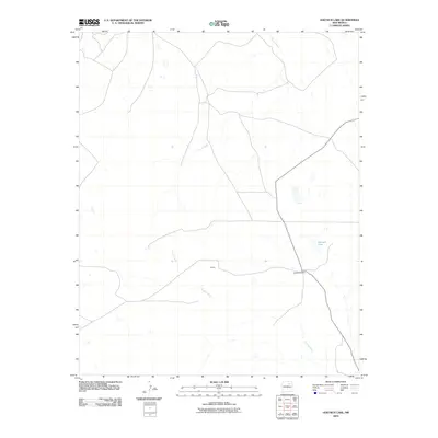
2010 Map of Goetsch Lake
USGS Topo · Published 2010About this map
Goetsch Ranch and the small settlement of Goods anchor this high plains landscape of northeastern San Miguel County. The terrain is defined by the drainage patterns of the Conchas River and Tipton Creek, which carve through the arid geography. The namesake Goetsch Lake appears as a distinct water feature in an area otherwise characterized by intermittent drainage and vast open spaces. This early 21st-century survey illustrates the persistent ranching character of the region, where named locations often represent family holdings or small supply points along the few arterial roads crossing the county.
Find a feature on this map
5 named features on this map. Tap any name to fly to it.
Don’t see what you’re looking for? This feature index may not catch every label — zoom into the map to look around manually.
Map Details
Editions of this 2010 Goetsch Lake Map
This is the sole edition of this map. No revisions or reprints were ever made.
Other maps of this area

1889 · Las Vegas
USGS Topo · 1:125,000

1891 · Las Vegas
USGS Topo · 1:125,000

1892 · Watrous
USGS Topo · 1:125,000

1893 · Las Vegas
USGS Topo · 1:125,000

1894 · Watrous
USGS Topo · 1:125,000

1954 · Santa Fe
USGS Topo · 1:250,000

1958 · Santa Fe
USGS Topo · 1:250,000
1963 · Las Vegas SE
USGS Topo · 1:24,000
1963 · Loma Parda
USGS Topo · 1:24,000
1963 · Onava
USGS Topo · 1:24,000