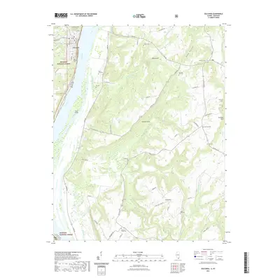
2021 Map of Golconda
USGS Topo · Published 2021About this map
Golconda sits on the western bank of the Ohio River, serving as a historic riverfront anchor where Pope County, Illinois, meets Livingston County, Kentucky. The landscape transitions from the river valley into the wooded uplands of the Shawnee National Forest, defined by a series of prominent high points like Newmans Bluff and Duley Bluff. This 2021 survey illustrates a region where family history and geography are deeply intertwined, evidenced by numerous small burial grounds scattered throughout the hills, such as Bingham Cem, Old Good Hope Cem, and McMurray Chapel Cem. Large river features like Pryor Island dominate the waterway, while inland drainages including McGilligan Cr and Whippoorwill Cr carve through the terrain. The map details the rural road network, from the river-hugging River Road to the winding tracks of Carrysville Road, connecting small settlements like Joy and Bay City to the county seat.
Find a feature on this map
70 named features on this map. Tap any name to fly to it.
Don’t see what you’re looking for? This feature index may not catch every label — zoom into the map to look around manually.
Map Details
Editions of this 2021 Golconda Map
This is the sole edition of this map. No revisions or reprints were ever made.
Other maps of this area

1916 · Golconda
USGS Topo · 1:62,500

1917 · Brownfield
USGS Topo · 1:62,500

1920 · Goloonda
USGS Topo · 1:48,000

1921 · Golconda
USGS Topo · 1:62,500

1926 · Paducah
USGS Topo · 1:62,500

1929 · Smithland
USGS Topo · 1:62,500

1929 · Paducah
USGS Topo · 1:62,500

1936 · Smithland
USGS Topo · 1:48,000

1940 · Paducah
USGS Topo · 1:62,500
1942 · Smithland
USGS Topo · 1:62,500