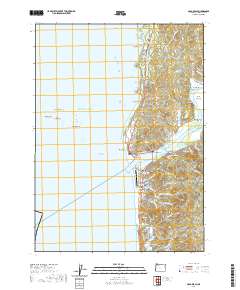
2020 Map of Gold Beach
USGS Topo · Published 2020About this map
The Rogue River meets the Pacific Ocean at this coastal juncture, dividing the community of Wedderburn to the north from Gold Beach to the south. This 2020 survey illustrates the developed coastal corridor along Ellensburg Ave and the Wedderburn Loop, where civic landmarks like the Curry County Courthouse and Gold Beach Municipal Airport anchor the local economy. Beyond the river mouth, the Rogue River Reef and its distinct sea stacks, including Double Rock and Needle Rock, define the protected waters of the Oregon Islands National Wildlife Refuge. Genealogists will find a high concentration of burial sites, from the coastal Geisel Cem and Pioneer Cem to the interior Smith Family Cem, while the river's path upstream reveals landmarks like Ferry Hole Bar and Johns Hole.
Find a feature on this map
90 named features on this map. Tap any name to fly to it.
Don’t see what you’re looking for? This feature index may not catch every label — zoom into the map to look around manually.
Map Details
Editions of this 2020 Gold Beach Map
This is the sole edition of this map. No revisions or reprints were ever made.
Other maps of this area

1899 · Port Orford
USGS Topo · 1:125,000

1903 · Port Orford
USGS Topo · 1:125,000

1954 · Coos Bay
USGS Topo · 1:250,000

1954 · Port Orford
USGS Topo · 1:62,500

1954 · Gold Beach
USGS Topo · 1:62,500

1958 · Coos Bay
USGS Topo · 1:250,000

1962 · Coos Bay
USGS Topo · 1:250,000
1986 · Ophir
USGS Topo · 1:24,000
1986 · Sundown Mtn
USGS Topo · 1:24,000
1986 · Cape Sebastian
USGS Topo · 1:24,000