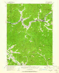
1954 Map of Gold Hill
USGS Topo · Published 1961About this map
The Rogue River and Applegate River valleys define the geography of Jackson and Josephine counties in the mid-1950s. The Southern Pacific railroad follows the winding course of the Rogue, connecting the settlements of Rogue River and Gold Hill while passing notable landmarks like Rock Point. This era shows a landscape shaped by both early industry and public infrastructure, from the Savage Rapids Dam to the gold-mining heritage evidenced by the Bill Nye Mine and Oregon Belle Mine.
Find a feature on this map
61 named features on this map. Tap any name to fly to it.
Don’t see what you’re looking for? This feature index may not catch every label — zoom into the map to look around manually.
Map Details
Editions of this 1954 Gold Hill Map
4 editions found

Other maps of this area

1891 · Ashland
USGS Topo · 1:250,000

1893 · Ashland
USGS Topo · 1:250,000

1897 · Ashland
USGS Topo · 1:250,000

1904 · Riddle
USGS Topo · 1:125,000

1908 · Grants Pass
USGS Topo · 1:125,000

1938 · Medford
USGS Topo · 1:125,000

1943 · Trail
USGS Topo · 1:62,500

1954 · Oregon Caves
USGS Topo · 1:62,500

1954 · Medford
USGS Topo · 1:62,500

1954 · Glendale
USGS Topo · 1:62,500