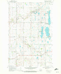
1970 Map of Golden Lake
USGS Topo · Published 1972About this map
Beaver Creek and the Middle Branch Goose River define the undulating prairie of eastern North Dakota in this 1970 snapshot of Steele County. The landscape is characterized by a complex network of wetlands and small basins, prominently featured in the Golden Lake State Wildlife Management Area. This territory shows a rural community anchored by centers of worship and remembrance, including Beaver Creek Church, Bethany Church, and a local Cemetery. The mapping of numerous Gravel Pits alongside a Gaging Station on Beaver Creek suggests a local economy and infrastructure tied directly to the land's geology and water resources during this era. Scattered farmsteads are connected by a grid of section lines and the primary thoroughfare of State Route 200, illustrating the organized settlement pattern of Westfield and Finley townships.
Find a feature on this map
15 named features on this map. Tap any name to fly to it.
Don’t see what you’re looking for? This feature index may not catch every label — zoom into the map to look around manually.
Map Details
Editions of this 1970 Golden Lake Map
This is the sole edition of this map. No revisions or reprints were ever made.
Other maps of this area

1952 · Grand Forks
USGS Topo · 1:250,000

1956 · Grand Forks
USGS Topo · 1:250,000

1966 · Grand Forks
USGS Topo · 1:250,000

1967 · Finley NE
USGS Topo · 1:24,000

1967 · Blabon
USGS Topo · 1:24,000

1967 · Finley
USGS Topo · 1:24,000

1968 · Hope NE
USGS Topo · 1:24,000

1968 · Sherbrooke
USGS Topo · 1:24,000
1970 · Northwood SE
USGS Topo · 1:24,000
1970 · Northwood NW
USGS Topo · 1:24,000
Featured Places
- Golden Lake Township, ND
- Westfield Township, ND
- Beaver Creek Township, ND
- Finley Township, ND
- Steele County, ND