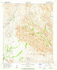
1956 Map of Goldfield
USGS Topo · Published 1963About this map
The mining camp of Goldfield sits at the base of the Goldfield Mountains, surrounded by several active and historic claims including the Tomahawk Mine, Bluebird Mine, and Black Queen Mine. This 1956 survey documents a landscape defined by its rugged mineral history and cattle ranching culture, featuring established homesteads like Kings Ranch and B Bar B Ranch. To the east, the vast Superstition Mountains dominate the terrain, where cultural artifacts such as Indian Hieroglyphics and Spanish Hieroglyphics are recorded near Hieroglyphic Spring. The map traces a network of drainage canyons like Boulder Canyon and La Barge Canyon carving through the high mesas, while the Apache Trail provides the primary transit route through this portion of the Tonto National Forest.
Find a feature on this map
53 named features on this map. Tap any name to fly to it.
Don’t see what you’re looking for? This feature index may not catch every label — zoom into the map to look around manually.
Map Details
Editions of this 1956 Goldfield Map
5 editions found

Other maps of this area

1900 · Florence
USGS Topo · 1:125,000

1902 · Florence
USGS Topo · 1:125,000

1904 · Desert Well
USGS Topo · 1:62,500

1904 · Ft. McDowell
USGS Topo · 1:62,500

1906 · Ft. McDowell
USGS Topo · 1:62,500

1906 · Desert Well
USGS Topo · 1:62,500

1907 · Roosevelt
USGS Topo · 1:125,000

1909 · Four Peaks
USGS Topo · 1:125,000

1912 · Roosevelt
USGS Topo · 1:125,000

1930 · Cave Creek
USGS Topo · 1:125,000