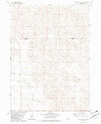
1982 Map of Goldman Lake SE
USGS Topo · Published 1982About this map
German Valley defines the southern portion of this Nebraska landscape, where the sand hills give way to a concentrated pocket of pioneer heritage. This 1982 edition preserves the locations of several multigenerational homesteads, including the Bear Trap Ranch, Snow Ranch, and the O Schneidereit Ranch. The social center of this rural community is anchored by the German Valley Cem, Prairie Bible Chapel, and St Johns Ch. Surveyed during the 1970s and finalized in the early 1980s, the map indicates a landscape shaped by ranching interests, with numerous wells and property boundaries crossing the border between Brown and Blaine Counties. The topography is characterized by intricate landforms, highlighting the isolation of individual holdings like the Fox Ranch and Cox Ranch.
Find a feature on this map
12 named features on this map. Tap any name to fly to it.
Don’t see what you’re looking for? This feature index may not catch every label — zoom into the map to look around manually.
Map Details
Editions of this 1982 Goldman Lake SE Map
This is the sole edition of this map. No revisions or reprints were ever made.
Other maps of this area

1952 · Brewster
USGS Topo · 1:24,000

1952 · Almeria NW
USGS Topo · 1:24,000

1952 · Brewster NW
USGS Topo · 1:24,000

1955 · Broken Bow
USGS Topo · 1:250,000

1955 · O'Neill
USGS Topo · 1:250,000

1956 · Broken Bow
USGS Topo · 1:250,000

1959 · O'Neill
USGS Topo · 1:250,000

1969 · O'Neill
USGS Topo · 1:250,000

1981 · Boiling Spring
USGS Topo · 1:24,000

1981 · Paramount Valley
USGS Topo · 1:24,000