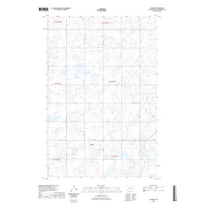
2020 Map of Goldwin
USGS Topo · Published 2020About this map
Goldwin stands as the primary settlement in this section of Stutsman County, situated at the junction of State Hwy 36 SE and Co Hwy 67. The surrounding landscape is defined by the high concentration of prairie potholes and larger water bodies characteristic of the Missouri Coteau region. Northwestern Lake and Alkali Lake dominate the central terrain, while West Lake and Eric Lake sit at the western and southern reaches. The geometric grid of section lines is maintained by a network of rural roads such as 61st Ave SE and 13th St SE, which navigate around the numerous wetlands. This 2020 update by the U.S. Geological Survey illustrates the persistent agricultural and hydrological patterns of the North Dakota plains, where the land is strictly divided by the Public Land Survey System even as water bodies shift and expand across the drainage-less basins.
Find a feature on this map
25 named features on this map. Tap any name to fly to it.
Don’t see what you’re looking for? This feature index may not catch every label — zoom into the map to look around manually.
Map Details
Editions of this 2020 Goldwin Map
This is the sole edition of this map. No revisions or reprints were ever made.
Other maps of this area

1948 · Carrington
USGS Topo · 1:62,500

1950 · Melville
USGS Topo · 1:24,000

1950 · Carrington SW
USGS Topo · 1:24,000

1952 · New Rockford
USGS Topo · 1:250,000

1956 · New Rockford
USGS Topo · 1:250,000
1958 · Vashti
USGS Topo · 1:24,000
1958 · Goldwin SE
USGS Topo · 1:24,000
1958 · Goldwin SW
USGS Topo · 1:24,000

1958 · Goldwin
USGS Topo · 1:24,000

1971 · New Rockford
USGS Topo · 1:250,000