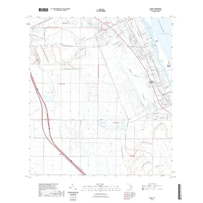
2021 Map of Gomez
USGS Topo · Published 2021About this map
Jupiter Island and the coastal settlements of Gomez and Hobe Sound define this contemporary maritime landscape along Florida's Treasure Coast. The map reveals a complex aquatic geography where the Indian River Lagoon and South Jupiter Narrows separate the barrier island from the mainland. Large conservation areas dominate the western interior, specifically the Atlantic Ridge Preserve State Park, which is crisscrossed by an extensive network of footpaths including the Atlantic Ridge Preserve State Park Trail and Steve's Trail. Educational and recreational landmarks are prominent, notably the Hobe Sound Bible College campus and the Intracoastal Waterway Peck Lake. The interface between the developed residential corridors and the South Fork Saint Lucie River basin highlights the modern balance of suburban expansion and environmental preservation in Martin County.
Find a feature on this map
117 named features on this map. Tap any name to fly to it.
Don’t see what you’re looking for? This feature index may not catch every label — zoom into the map to look around manually.
Map Details
Editions of this 2021 Gomez Map
This is the sole edition of this map. No revisions or reprints were ever made.
Other maps of this area

1948 · Palm City
USGS Topo · 1:24,000

1948 · Rood
USGS Topo · 1:24,000

1948 · St. Lucie Inlet
USGS Topo · 1:24,000

1948 · Gomez
USGS Topo · 1:24,000

1948 · Hobe Sound
USGS Topo · 1:24,000

1948 · Jupiter
USGS Topo · 1:24,000

1949 · Rood
USGS Topo · 1:24,000

1949 · Gomez
USGS Topo · 1:24,000

1949 · Hobe Sound
USGS Topo · 1:24,000

1950 · St. Lucie Inlet
USGS Topo · 1:24,000