
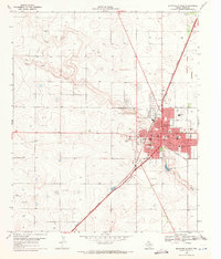
1969 Map of Gomez
USGS Topo · Published 1971About this map
Lost Draw meanders through this portion of Terry County, defining a landscape marked by the agricultural and industrial patterns of the late 1960s. The small settlement of Gomez sits along the eastern edge of the survey, while Johnson occupies a central position to the west. This area of the Texas South Plains is characterized by numerous wells and several water tanks scattered across the grid-like property divisions, indicating the importance of groundwater management in this semi-arid region. In addition to water resources, evidence of local extraction appears in the form of a Gravel Pit and a prominent Pipeline that cuts across the southern terrain. This survey, compiled from 1968 aerial photography and 1969 planetable methods, preserves the exact locations of survey markers like BM 3388 and the network of unimproved roads that connected these High Plains communities before modern expansion.
Find a feature on this map
10 named features on this map. Tap any name to fly to it.
Don’t see what you’re looking for? This feature index may not catch every label — zoom into the map to look around manually.
Map Details
Editions of this 1969 Gomez Map
This is the sole edition of this map. No revisions or reprints were ever made.
Other maps of this area

1954 · Brownfield
USGS Topo · 1:250,000

1958 · Brownfield
USGS Topo · 1:250,000

1962 · Brownfield
USGS Topo · 1:250,000

1969 · Plains 1 SE
USGS Topo · 1:24,000

1969 · Foster
USGS Topo · 1:24,000

1969 · Sundown SE
USGS Topo · 1:24,000

1969 · Pool
USGS Topo · 1:24,000

1969 · Wellman
USGS Topo · 1:24,000
1969 · Brownfield West
USGS Topo · 1:24,000

1970 · Tokio
USGS Topo · 1:24,000