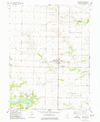
1974 Map of Good Hope
USGS Topo · Published 1978About this map
Good Hope and Sciota anchor this central Illinois landscape during the mid-1970s, a region defined by the intersection of productive prairie farmland and the meandering drainage of the East Fork La Moine River. The Toledo Peoria and Western railroad corridor cuts a straight line through the territory, linking the small grain-handling centers. Local history is preserved at the Hickory Grove Cem and Good Hope Cem, while the southern portion of the quadrangle shows the development of recreation and infrastructure, including Spring Lake and the Camp Chic-A-Gami youth camp. The survey also captures a moment of modern transition for the county seat's periphery, featuring the Macomb Municipal Airport and Northwestern High School. The terrain is marked by the distinct dendritic patterns of the Town Fork and Farmers Fork as they carve into the agricultural upland.
Find a feature on this map
25 named features on this map. Tap any name to fly to it.
Don’t see what you’re looking for? This feature index may not catch every label — zoom into the map to look around manually.
Map Details
Editions of this 1974 Good Hope Map
This is the sole edition of this map. No revisions or reprints were ever made.
Other maps of this area

1912 · Macomb
USGS Topo · 1:62,500

1913 · Colchester
USGS Topo · 1:62,500

1914 · Macomb
USGS Topo · 1:62,500

1916 · Good Hope
USGS Topo · 1:62,500

1918 · La Harpe
USGS Topo · 1:62,500

1918 · Good Hope
USGS Topo · 1:62,500

1958 · Burlington
USGS Topo · 1:250,000

1961 · Burlington
USGS Topo · 1:250,000

1963 · Burlington
USGS Topo · 1:250,000
1974 · Bardolph
USGS Topo · 1:24,000