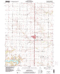
1998 Map of Good Hope
USGS Topo · Published 2000About this map
The village of Good Hope serves as a central hub in this McDonough County landscape, situated at a major crossroads north of Macomb. The surrounding terrain is defined by the intricate drainage systems of the Little East Fork La Moine River and several named tributaries including Town Fork, Short Fork, and Farmers Fork. These waterways cut through the agricultural sections of Sciota and Walnut Grove, creating a distinct pattern of wooded creek beds and upland fields.
Find a feature on this map
27 named features on this map. Tap any name to fly to it.
Don’t see what you’re looking for? This feature index may not catch every label — zoom into the map to look around manually.
Map Details
Editions of this 1998 Good Hope Map
This is the sole edition of this map. No revisions or reprints were ever made.
Other maps of this area

1912 · Macomb
USGS Topo · 1:62,500

1913 · Colchester
USGS Topo · 1:62,500

1914 · Macomb
USGS Topo · 1:62,500

1916 · Good Hope
USGS Topo · 1:62,500

1918 · La Harpe
USGS Topo · 1:62,500

1918 · Good Hope
USGS Topo · 1:62,500

1958 · Burlington
USGS Topo · 1:250,000

1961 · Burlington
USGS Topo · 1:250,000

1963 · Burlington
USGS Topo · 1:250,000
1974 · Bardolph
USGS Topo · 1:24,000