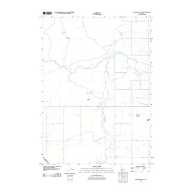
2010 Map of Gooding Butte
USGS Topo · Published 2010About this map
The Malad River and its confluence with the Big Wood River and Little Wood River define the hydraulic character of this high desert region in southern Idaho. This 2010 survey illustrates the complex irrigation network vital to the local agricultural economy, prominently featuring the South Gooding Main Canal and several man-made catchments such as Tea Kettle Reservoir, Rocky Reservoir, and Open Crossing Reservoir. The landscape is etched with a rigid grid of rural roads like S 1200 E and E 1800 S, which service the scattered rural homesteads and the small settlement of Fuller. To the east, the volcanic origin of the terrain is represented by Gooding Butte, which overlooks the Gooding Municipal Airport. The presence of features like Walker Waterhole and Dry Creek suggests the seasonal variability of water in this environment, where engineering has redirected natural flows to support life on the Snake River Plain.
Find a feature on this map
30 named features on this map. Tap any name to fly to it.
Don’t see what you’re looking for? This feature index may not catch every label — zoom into the map to look around manually.
Map Details
Editions of this 2010 Gooding Butte Map
This is the sole edition of this map. No revisions or reprints were ever made.
Other maps of this area

1949 · Bliss
USGS Topo · 1:24,000

1949 · Gooding Butte
USGS Topo · 1:24,000

1949 · Tuttle
USGS Topo · 1:24,000

1949 · Hagerman
USGS Topo · 1:24,000

1950 · Gooding Butte
USGS Topo · 1:24,000

1950 · Hagerman
USGS Topo · 1:24,000

1950 · Bliss
USGS Topo · 1:24,000

1951 · Tuttle
USGS Topo · 1:24,000

1955 · Twin Falls
USGS Topo · 1:250,000

1955 · Hailey
USGS Topo · 1:250,000