
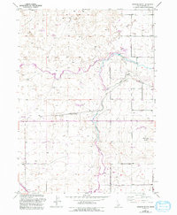
1950 Map of Gooding Butte
USGS Topo · Published 1950About this map
The confluence of high-desert water management and rail transportation is evident on this 1950 map of south-central Idaho. The Big Wood River and Little Wood River converge in the eastern portion of the quadrangle, feeding a complex network of man-made waterways including the Gooding Main Canal and various irrigation ditches. These features represent the mid-century agricultural development of the Snake River Plain, where water diversion transformed the arid landscape.
Find a feature on this map
17 named features on this map. Tap any name to fly to it.
Don’t see what you’re looking for? This feature index may not catch every label — zoom into the map to look around manually.
Map Details
Editions of this 1950 Gooding Butte Map
2 editions found
Other maps of this area

1949 · Bliss
USGS Topo · 1:24,000

1949 · Gooding Butte
USGS Topo · 1:24,000

1949 · Tuttle
USGS Topo · 1:24,000

1949 · Hagerman
USGS Topo · 1:24,000

1950 · Hagerman
USGS Topo · 1:24,000

1950 · Bliss
USGS Topo · 1:24,000

1951 · Tuttle
USGS Topo · 1:24,000

1955 · Twin Falls
USGS Topo · 1:250,000

1955 · Hailey
USGS Topo · 1:250,000

1957 · Thorn Creek SW
USGS Topo · 1:24,000