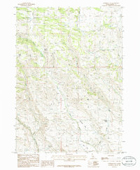
1986 Map of Goodman Flat
USGS Topo · Published 1986About this map
Boise National Forest land dominates the northwestern corner of this territory, where the drainage systems of Little Camas Creek and Little Canyon Creek carve through the high Idaho terrain. The map captures a high-plateau landscape defined by seasonal water sources and complex topography, notably at Goodman Flat and the surrounding drainages of Goodman Flat Creek and Babs Flat Creek. These areas show the intricate network of canyons that feed southward toward the Snake River plain.
Find a feature on this map
18 named features on this map. Tap any name to fly to it.
Don’t see what you’re looking for? This feature index may not catch every label — zoom into the map to look around manually.
Map Details
Editions of this 1986 Goodman Flat Map
This is the sole edition of this map. No revisions or reprints were ever made.
Other maps of this area

1892 · Camas Prairie
USGS Topo · 1:125,000

1893 · Camas Prairie
USGS Topo · 1:125,000

1955 · Hailey
USGS Topo · 1:250,000
1958 · Bennett Mtn
USGS Topo · 1:62,500

1958 · King Hill
USGS Topo · 1:62,500

1959 · Hailey
USGS Topo · 1:250,000

1962 · Hailey
USGS Topo · 1:250,000

1963 · High Prairie
USGS Topo · 1:24,000
1973 · Anderson Ranch Dam
USGS Topo · 1:24,000
1973 · Cat Creek Summit
USGS Topo · 1:24,000