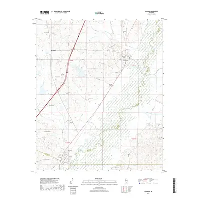
2020 Map of Goodman
USGS Topo · Published 2020About this map
Holmes Community College stands as a central landmark in Goodman, surrounded by a landscape defined by the winding course of the Big Black River. This river corridor serves as a significant county boundary, separating Holmes County from Attala County to the east and Madison County to the south. Further south, the town of Pickens is situated near the confluence of local water systems like Bisland Bayou and Seneasha Creek. The terrain is marked by numerous family and community burial sites, including the Moore Family Cem and Quiet Ridge Cem, which provide valuable location data for genealogists tracing local families. Small rural settlements like Richland and the presence of Peterson Airport illustrate the mix of educational, agricultural, and transportation infrastructure that supports this Central Mississippi region. The dense network of local routes, such as Saint Marys Church Rd and Ebenezer Pickens Rd, connects these communities across a terrain etched by tributary systems like Box Cr and Mills Cr.
Find a feature on this map
71 named features on this map. Tap any name to fly to it.
Don’t see what you’re looking for? This feature index may not catch every label — zoom into the map to look around manually.
Map Details
Editions of this 2020 Goodman Map
This is the sole edition of this map. No revisions or reprints were ever made.
Other maps of this area

1940 · Lexington
USGS Topo · 1:62,500

1953 · Meridian
USGS Topo · 1:250,000

1953 · Greenwood
USGS Topo · 1:250,000

1953 · West Point
USGS Topo · 1:250,000

1955 · Jackson
USGS Topo · 1:250,000

1956 · Greenwood
USGS Topo · 1:250,000

1957 · Meridian
USGS Topo · 1:250,000

1957 · Lexington
USGS Topo · 1:62,500

1958 · West Point
USGS Topo · 1:250,000

1958 · Lexington
USGS Topo · 1:62,500