
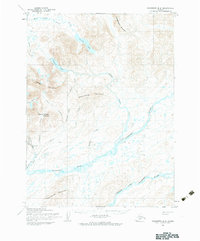
1954 Map of Goodnews B-6
USGS Topo · Published 1968About this map
Goodnews River and its major tributaries define this mid-century Alaskan landscape, revealing a remote wilderness shaped by early resource extraction and indigenous movement. The confluence of the Middle Fork Goodnews River and the main channel anchors the lower quadrant, while the high ground is dominated by prominent peaks such as Atlakumtsitak Mountain and Chingekigtlik Mountain. Evidence of human activity is concentrated along the western waterways, where a Native Trail parallels Slate Creek.
Find a feature on this map
27 named features on this map. Tap any name to fly to it.
Don’t see what you’re looking for? This feature index may not catch every label — zoom into the map to look around manually.
Map Details
Editions of this 1954 Goodnews B-6 Map
2 editions found
Other maps of this area

1951 · Goodnews
USGS Topo · 1:250,000

1954 · Goodnews B-7
USGS Topo · 1:63,360

1954 · Goodnews A-7
USGS Topo · 1:63,360

1954 · Goodnews C-7
USGS Topo · 1:63,360

1954 · Goodnews A-6
USGS Topo · 1:63,360

1954 · Goodnews C-6
USGS Topo · 1:63,360

1979 · Goodnews Bay C-5
USGS Topo · 1:63,360

1979 · Goodnews Bay A-5
USGS Topo · 1:63,360

1979 · Goodnews Bay B-5
USGS Topo · 1:63,360

1979 · Goodnews Bay
USGS Topo · 1:250,000