
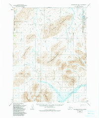
1954 Map of Goodnews B-7
USGS Topo · Published 1965About this map
Island Mountain and the surrounding peaks of the Kuskokwim region dominate this mid-century survey, illustrating a landscape defined by complex drainage systems and high-altitude terrain. The map documents an intricate network of waterways including the Arolik River and the Goodnews River, which served as primary corridors for movement through this wilderness. While mostly uninhabited, the presence of Cabins along Red Lodge Creek and several segments of Native Trail indicate seasonal use and subsistence routes through the mountains. Names like Lucky Gulch, Wattamuse Creek, and Colorado Creek suggest a history of prospecting and resource exploration. These labels provide crucial context for the mining and indigenous history of the Bethel area, showing how human activity followed the valley floors between ridges like Tatlignagpeke Mountain and Nagotligageivik Mountain.
Find a feature on this map
35 named features on this map. Tap any name to fly to it.
Don’t see what you’re looking for? This feature index may not catch every label — zoom into the map to look around manually.
Map Details
Editions of this 1954 Goodnews B-7 Map
2 editions found
Other maps of this area

1951 · Goodnews
USGS Topo · 1:250,000

1954 · Goodnews A-8
USGS Topo · 1:63,360

1954 · Goodnews A-7
USGS Topo · 1:63,360

1954 · Goodnews B-8
USGS Topo · 1:63,360

1954 · Goodnews C-7
USGS Topo · 1:63,360

1954 · Goodnews A-6
USGS Topo · 1:63,360

1954 · Goodnews B-6
USGS Topo · 1:63,360

1954 · Goodnews C-6
USGS Topo · 1:63,360
1954 · Goodnews C-8
USGS Topo · 1:63,360

1979 · Goodnews Bay
USGS Topo · 1:250,000