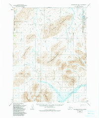
1954 Map of Goodnews Bay B-7
USGS Topo · Published 1984About this map
Island Mountain and the surrounding peaks of the Ahklun Mountains dominate this mid-century survey of the Alaskan interior within the Togiak National Wildlife Refuge. The landscape is defined by an intricate drainage system where the Goodnews River and Arolik River receive flow from numerous high-altitude sources, including Wattamuse Creek and Cascade Creek. The presence of a Native Trail traversing the northern ridges toward Midas Creek suggests established routes through these highlands, connecting the drainages of Deer Creek and the Arolik River.
Find a feature on this map
37 named features on this map. Tap any name to fly to it.
Don’t see what you’re looking for? This feature index may not catch every label — zoom into the map to look around manually.
Map Details
Editions of this 1954 Goodnews Bay B-7 Map
2 editions found
Other maps of this area

1951 · Goodnews
USGS Topo · 1:250,000

1954 · Goodnews A-8
USGS Topo · 1:63,360

1954 · Goodnews B-7
USGS Topo · 1:63,360

1954 · Goodnews A-7
USGS Topo · 1:63,360

1954 · Goodnews B-8
USGS Topo · 1:63,360

1954 · Goodnews C-7
USGS Topo · 1:63,360

1954 · Goodnews A-6
USGS Topo · 1:63,360

1954 · Goodnews B-6
USGS Topo · 1:63,360

1954 · Goodnews C-6
USGS Topo · 1:63,360
1954 · Goodnews C-8
USGS Topo · 1:63,360