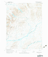
1954 Map of Goodnews B-6
USGS Topo · Published 1984About this map
Atlakumtsitak Mountain and Chingekigtlik Mountain dominate the rugged interior of this southwestern Alaska region, where high peaks overlook a complex network of glacial lakes and river forks. In the mid-1950s, the landscape remained largely untouched by major development, defined instead by seasonal activity and subsistence routes. Evidence of previous industry appears at the Mining Camp (Abandoned) located near Wattimuse Creek and Cascade Creek, while a lonely Cabin and a remote Airfield indicate the sparse human footprint.
Find a feature on this map
25 named features on this map. Tap any name to fly to it.
Don’t see what you’re looking for? This feature index may not catch every label — zoom into the map to look around manually.
Map Details
Editions of this 1954 Goodnews B-6 Map
2 editions found
Other maps of this area

1951 · Goodnews
USGS Topo · 1:250,000

1954 · Goodnews B-7
USGS Topo · 1:63,360

1954 · Goodnews A-7
USGS Topo · 1:63,360

1954 · Goodnews C-7
USGS Topo · 1:63,360

1954 · Goodnews A-6
USGS Topo · 1:63,360

1954 · Goodnews B-6
USGS Topo · 1:63,360

1954 · Goodnews C-6
USGS Topo · 1:63,360

1979 · Goodnews Bay C-5
USGS Topo · 1:63,360

1979 · Goodnews Bay A-5
USGS Topo · 1:63,360

1979 · Goodnews Bay B-5
USGS Topo · 1:63,360