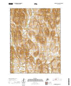
2020 Map of Goodnews Bay A-5 SW
USGS Topo · Published 2020About this map
Matogak River snakes through the center of this remote landscape, defining the transition between the Bethel Census Area and the Dillingham Census Area. The terrain is characterized by complex hydrology, with the Quigmy River visible in the southeastern corner. This 2020 survey documents the intricate network of wetlands and seasonal water channels that dominate the southwestern corner of the Goodnews Bay A-5 quadrangle. Without road access or permanent settlements, the map reveals the pristine character of the Alaskan wilderness as it appeared in the early 21st century, providing a baseline for environmental and hydrological studies in this isolated coastal region.
Find a feature on this map
8 named features on this map. Tap any name to fly to it.
Don’t see what you’re looking for? This feature index may not catch every label — zoom into the map to look around manually.
Map Details
Editions of this 2020 Goodnews Bay A-5 SW Map
This is the sole edition of this map. No revisions or reprints were ever made.
Other maps of this area

1948 · Hagemeister Island D-3
USGS Topo · 1:63,360

1951 · Goodnews
USGS Topo · 1:250,000

1951 · Hagemeister Island
USGS Topo · 1:250,000

1954 · Goodnews A-6
USGS Topo · 1:63,360

1957 · Hagemeister Island
USGS Topo · 1:250,000

1979 · Goodnews Bay A-5
USGS Topo · 1:63,360

1979 · Goodnews Bay
USGS Topo · 1:250,000
2018 · Hagemeister Island D-3 NW
USGS Topo · 1:25,000
2018 · Hagemeister Island D-3 NE
USGS Topo · 1:25,000
2020 · Goodnews Bay A-5 NE
USGS Topo · 1:25,000