
1951 Map of Hagemeister Island
USGS Topo · Published 1953About this map
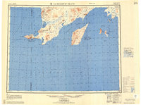
Platinum sits at the edge of Kuskokwim Bay on this 1951 survey, a remote coastal outpost defined by its proximity to the mineral-rich mountains of the southwest Alaska peninsula. The map delineates a rugged coastal landscape where the Fourth Judicial Division meets the Third Judicial Division near the winding course of the Slug River. Offshore, the large landmass of Hagemeister Island dominates the Hagemeister Strait, flanked by the smaller Walrus Islands chain including High Island and Crooked Island. This mid-century reconnaissance reveals a territory still largely accessed by air and sea, noted by the Landing Area near the coast and a solitary Winter Trail cutting through the interior. From the jagged peaks of Oracle Mtn to the wide expanse of Togiak Bay, the sheet documents the essential landmarks for navigation in the Bristol Bay region.
Find a feature on this map
61 named features on this map. Tap any name to fly to it.
Don’t see what you’re looking for? This feature index may not catch every label — zoom into the map to look around manually.
Map Details
Editions of this 1951 Hagemeister Island Map
2 editions found
Other maps of this area

1945 · Nushagak Bay
USGS Topo · 1:250,000
1947 · Hagemeister Island C-7
USGS Topo · 1:63,360

1947 · Hagemeister Island D-2
USGS Topo · 1:63,360

1948 · Hagemeister Island D-3
USGS Topo · 1:63,360

1948 · Hagemeister Island C-6
USGS Topo · 1:63,360

1948 · Hagemeister Island C-4
USGS Topo · 1:63,360

1948 · Hagemeister Island C-3
USGS Topo · 1:63,360
1948 · Hagemeister Island C-2
USGS Topo · 1:63,360

1948 · Hagemeister Island C-1
USGS Topo · 1:63,360

1948 · Hagemeister Island C-5
USGS Topo · 1:63,360