
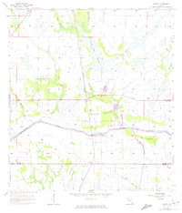
1958 Map of Goodno
USGS Topo · Published 1959About this map
Coffee Mill Hammock and the surrounding wet prairies of south-central Florida are the central focus of this 1958 survey. The landscape is defined by the managed waters of the Caloosahatchee Canal, where the Ortona Lock Spillway 10 regulates flow through the Glades. Early human occupation and historical land use are evident in the Indian Mound near Ortona and the presence of an Old Railroad Grade running through the southern section of the quadrangle. Small settlements like Citrus Center and Goodno are connected by a network of drainage features and hammocks, including Long Hammock. This map provides a look at the region’s topography before extensive modern development, detailing the intricate system of branches like Deadmans Branch and Turkey Branch that drain into the Linden Pens Marsh.
Find a feature on this map
18 named features on this map. Tap any name to fly to it.
Don’t see what you’re looking for? This feature index may not catch every label — zoom into the map to look around manually.
Map Details
Editions of this 1958 Goodno Map
2 editions found
Other maps of this area

1956 · West Palm Beach
USGS Topo · 1:250,000

1957 · West Palm Beach
USGS Topo · 1:250,000

1958 · West Palm Beach
USGS Topo · 1:250,000

1958 · La Belle NW
USGS Topo · 1:24,000

1958 · Felda NE
USGS Topo · 1:24,000

1958 · Sears
USGS Topo · 1:24,000
1958 · La Belle
USGS Topo · 1:24,000
1958 · Palmdale
USGS Topo · 1:24,000
1970 · Lakeport
USGS Topo · 1:24,000

1970 · La Belle 4 NW
USGS Topo · 1:24,000