
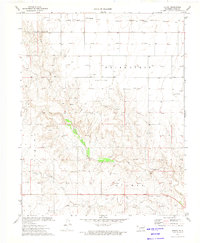
1973 Map of Goodwell NE
USGS Topo · Published 1975About this map
The Beaver River winds through this Panhandle landscape, illustrating the industrial and agricultural character of the early 1970s. The region is defined by extensive energy development, with numerous gas wells and pipelines dotting the terrain between Guymon and Goodwell. The influence of the transportation and aviation sectors is evident along the eastern margin, where the Chicago Rock Island and Pacific railroad tracks parallel the Guymon Corporate Boundary and the Guymon Municipal Airport.
Find a feature on this map
15 named features on this map. Tap any name to fly to it.
Don’t see what you’re looking for? This feature index may not catch every label — zoom into the map to look around manually.
Map Details
Editions of this 1973 Goodwell NE Map
This is the sole edition of this map. No revisions or reprints were ever made.
Other maps of this area

1954 · Perryton
USGS Topo · 1:250,000

1958 · Perryton
USGS Topo · 1:250,000

1967 · Straight SW
USGS Topo · 1:24,000

1968 · Guymon
USGS Topo · 1:24,000

1968 · Guymon SW
USGS Topo · 1:24,000

1973 · Goodwell SE
USGS Topo · 1:24,000

1973 · Goodwell NW
USGS Topo · 1:24,000

1973 · Hough SW
USGS Topo · 1:24,000

1973 · Goodwell
USGS Topo · 1:24,000
1973 · Hough
USGS Topo · 1:24,000