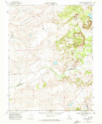
1968 Map of Goose Creek
USGS Topo · Published 1972About this map
Hadselville serves as a focal point in this Central Valley landscape, situated at the junction of several drainage systems and the Pacific Southern rail line. The map captures a transition between the flatter agricultural plains to the west and the rising foothills to the east, marked by the prominent Arroyo Seco and Yellow Hill. A legacy of industrial activity is evident in the Dredge Tailings near Clay East Road, revealing how the search for minerals reshaped the local topography.
Find a feature on this map
19 named features on this map. Tap any name to fly to it.
Don’t see what you’re looking for? This feature index may not catch every label — zoom into the map to look around manually.
Map Details
Editions of this 1968 Goose Creek Map
4 editions found

Other maps of this area

1889 · Jackson
USGS Topo · 1:125,000

1892 · Jackson
USGS Topo · 1:125,000

1894 · Lodi
USGS Topo · 1:125,000

1897 · Jackson
USGS Topo · 1:125,000

1902 · Jackson
USGS Topo · 1:125,000

1908 · Lockeford
USGS Topo · 1:31,680

1909 · Carbondale
USGS Topo · 1:31,680

1909 · Clay
USGS Topo · 1:31,680

1909 · Cosumnes
USGS Topo · 1:31,680

1909 · Goose Creek
USGS Topo · 1:31,680