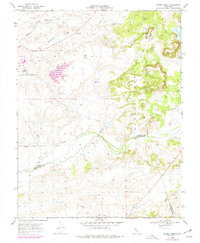
1968 Map of Goose Creek
USGS Topo · Published 1977About this map
Hadselville serves as the primary focal point of this Central Valley landscape, situated along the Southern Pacific railroad line during the late 1960s. The terrain is defined by its complex drainage network, where Dry Creek and Arroyo Seco carve through the land alongside Goose Creek. Significant industrial history is evident through extensive Dredge Tailings and a localized Powerplant, indicating the lingering footprint of resource extraction and utility development in this rural corridor. Revisions from 1975 aerial photography highlight changes in land use near Clay East Road and Borden Road. This survey captures the intersection of three counties—Sacramento, San Joaquin, and Amador—mapping the transition from the alluvial floor toward landmarks like Yellow Hill.
Find a feature on this map
21 named features on this map. Tap any name to fly to it.
Don’t see what you’re looking for? This feature index may not catch every label — zoom into the map to look around manually.
Map Details
Editions of this 1968 Goose Creek Map
4 editions found

Other maps of this area

1889 · Jackson
USGS Topo · 1:125,000

1892 · Jackson
USGS Topo · 1:125,000

1894 · Lodi
USGS Topo · 1:125,000

1897 · Jackson
USGS Topo · 1:125,000

1902 · Jackson
USGS Topo · 1:125,000

1908 · Lockeford
USGS Topo · 1:31,680

1909 · Carbondale
USGS Topo · 1:31,680

1909 · Clay
USGS Topo · 1:31,680

1909 · Cosumnes
USGS Topo · 1:31,680

1909 · Goose Creek
USGS Topo · 1:31,680