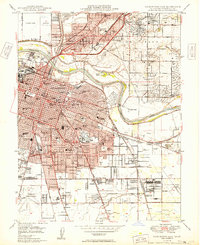
1949 Map of Sacramento East
USGS Topo · Published 1949About this map
Sacramento and its eastern suburbs are shown here just after the war, a landscape where established neighborhoods like Oak Park and the historic Sutter Fort meet the rapid post-war expansion into the Del Paso area. The urban grid is heavily defined by the Southern Pacific and Sacramento Northern rail lines, which link industrial zones and the sprawling State Fairgrounds to the wider Central Valley. Significant public works and military investments are evident at the U S Army Signal Depot and the Sacramento Municipal Airport.
Find a feature on this map
109 named features on this map. Tap any name to fly to it.
Don’t see what you’re looking for? This feature index may not catch every label — zoom into the map to look around manually.
Map Details
Editions of this 1949 Sacramento East Map
2 editions found
Other maps of this area

1891 · Sacramento
USGS Topo · 1:125,000

1892 · Sacramento
USGS Topo · 1:125,000

1893 · Sacramento
USGS Topo · 1:125,000

1894 · Lodi
USGS Topo · 1:125,000

1902 · Fairoaks
USGS Topo · 1:62,500

1907 · Davisville
USGS Topo · 1:62,500

1908 · Courtland
USGS Topo · 1:62,500

1909 · Elk Grove
USGS Topo · 1:31,680

1909 · Florin
USGS Topo · 1:31,680

1911 · Brighton
USGS Topo · 1:31,680