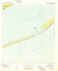
1950 Map of Goose Island
USGS Topo · Published 1950About this map
The coastal village of Eastpoint anchors the northwestern corner of this 1950 survey, serving as the gateway to the intricate barrier system of St George Island. This mid-century view captures the coastline before extensive modern development, highlighting a landscape defined by shifting dunes and tidal inlets. Along the island's narrow stretch, maritime landmarks like Old Landing and the light near Goose Island suggest a history of local navigation and fishing commerce. The geography is characterized by sheltered waters such as Rattlesnake Cove and Shell Point Cove, which are separated from the open Gulf of Mexico by the island’s slender profile. On the mainland, the Eastpoint Cemetery provides a specific point of interest for genealogists tracing early families of this Franklin County community during a period when the local economy was deeply tied to the surrounding St George Sound.
Find a feature on this map
19 named features on this map. Tap any name to fly to it.
Don’t see what you’re looking for? This feature index may not catch every label — zoom into the map to look around manually.
Map Details
Editions of this 1950 Goose Island Map
4 editions found
Other maps of this area

1943 · Apalachicola
USGS Topo · 1:31,680

1943 · Carrabelle
USGS Topo · 1:24,000

1944 · Carrabelle
USGS Topo · 1:31,680

1944 · Green Point
USGS Topo · 1:31,680

1944 · Sugar Hill
USGS Topo · 1:31,680

1944 · Apalachicola
USGS Topo · 1:24,000

1945 · Sugar Hill
USGS Topo · 1:31,680

1945 · Beverly
USGS Topo · 1:31,680

1949 · Apalachicola
USGS Topo · 1:250,000

1950 · Goose Island
USGS Topo · 1:31,680