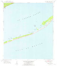
1950 Map of Goose Island
USGS Topo · Published 1960About this map
St George Island stretches across the southern half of this mid-century survey, separating the Gulf of Mexico from the shallow waters of St George Sound. The island's geography is defined by a series of sand dunes, marshy inlets, and distinct coastal points such as Bulkhead Pt, Shell Point, and Gap Point. Small water bodies like Rattlesnake Cove and East Slough indent the shoreline, while the isolated Goose Island sits off the northern coast of the main barrier. On the mainland to the northwest, the settlement of Eastpoint marks the edge of the sound, served by the coastal route 319. This map provides a clear record of the area's shoreline before major modern development, noting the Eastpoint Cem and a remote Old Landing on the barrier island, suggesting early access points for fishing or transport.
Find a feature on this map
18 named features on this map. Tap any name to fly to it.
Don’t see what you’re looking for? This feature index may not catch every label — zoom into the map to look around manually.
Map Details
Editions of this 1950 Goose Island Map
4 editions found
Other maps of this area

1943 · Apalachicola
USGS Topo · 1:31,680

1943 · Carrabelle
USGS Topo · 1:24,000

1944 · Carrabelle
USGS Topo · 1:31,680

1944 · Green Point
USGS Topo · 1:31,680

1944 · Sugar Hill
USGS Topo · 1:31,680

1944 · Apalachicola
USGS Topo · 1:24,000

1945 · Sugar Hill
USGS Topo · 1:31,680

1945 · Beverly
USGS Topo · 1:31,680

1949 · Apalachicola
USGS Topo · 1:250,000

1950 · Goose Island
USGS Topo · 1:31,680