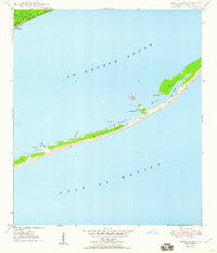
1950 Map of Goose Island
USGS Topo · Published 1960About this map
St George Island stretches across this mid-century survey, forming a narrow barrier between the open Gulf of Mexico and the calmer waters of St George Sound. The island's geography is defined by a series of inlets and points, including the prominent Bulkhead Pt and Gap Point. On the mainland, the settlement of Eastpoint anchors the northwestern corner of the sheet, providing a gateway to the coast via Route 319.
Find a feature on this map
18 named features on this map. Tap any name to fly to it.
Don’t see what you’re looking for? This feature index may not catch every label — zoom into the map to look around manually.
Map Details
Editions of this 1950 Goose Island Map
4 editions found
Other maps of this area

1943 · Apalachicola
USGS Topo · 1:31,680

1943 · Carrabelle
USGS Topo · 1:24,000

1944 · Carrabelle
USGS Topo · 1:31,680

1944 · Green Point
USGS Topo · 1:31,680

1944 · Sugar Hill
USGS Topo · 1:31,680

1944 · Apalachicola
USGS Topo · 1:24,000

1945 · Sugar Hill
USGS Topo · 1:31,680

1945 · Beverly
USGS Topo · 1:31,680

1949 · Apalachicola
USGS Topo · 1:250,000

1950 · Goose Island
USGS Topo · 1:31,680