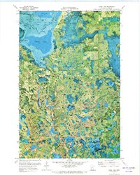
1971 Map of Goose Lake
USGS Topo · Published 1974About this map
Leech Lake Indian Res occupies the northern reaches of this territory, where the waters of Leech Lake and Goose Lake dominate a landscape defined by glacial lakes and wetlands. The intricate hydrography of north-central Minnesota is on full display, with the Boy River winding through the Chippewa National Forest and Bowstring State Forest. Small settlements like Elevenmile Corner provide a sense of the sparse human footprint in this heavily forested region during the early 1970s. The map illustrates a complex network of smaller water bodies, including the descriptively named Dirty Nose Lake, Zimmerman Lake, and Grave Lake. Scattered Gravel Pits suggest the importance of local material extraction for maintaining the area's light-duty road network, while the presence of Bear Island and Mud Lake underscores the preserved wilderness character of the Cass County backcountry.
Find a feature on this map
33 named features on this map. Tap any name to fly to it.
Don’t see what you’re looking for? This feature index may not catch every label — zoom into the map to look around manually.
Map Details
Editions of this 1971 Goose Lake Map
This is the sole edition of this map. No revisions or reprints were ever made.
Other maps of this area

1954 · Bemidji
USGS Topo · 1:250,000

1954 · Hibbing
USGS Topo · 1:250,000

1957 · Bemidji
USGS Topo · 1:250,000

1957 · Hibbing
USGS Topo · 1:250,000

1958 · Bemidji
USGS Topo · 1:250,000

1958 · Hibbing
USGS Topo · 1:250,000

1964 · Hibbing
USGS Topo · 1:250,000
1970 · Deer River
USGS Topo · 1:24,000

1970 · Ball Club
USGS Topo · 1:24,000
1971 · Remer
USGS Topo · 1:24,000