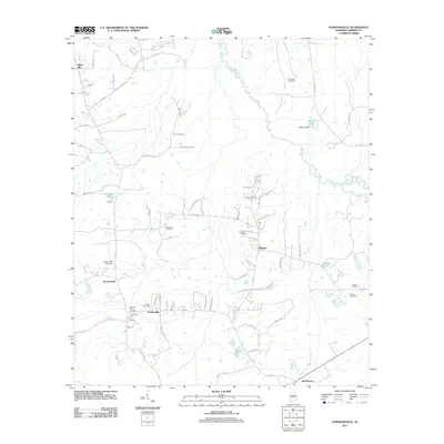
2011 Map of Gordonsville
USGS Topo · Published 2011About this map
Mosses and Gordonsville anchor this Lowndes County landscape, showing a pattern of small-scale settlement connected by local roads like Mary J Jackson Rd and Black Belt. The area is notably dense with family and community burial grounds, including Hope Well Cemetery, Garr Cemetery, and Bogahoma Cemetery, which serve as vital markers for local genealogy. To the east, the meandering Big Swamp Creek dictates the drainage of the terrain, feeding into several smaller bodies of water such as Martins Lake and Hollidays Pond. The presence of Silver Creek Farm and the Bessie Beck Lake Dam reflects the agricultural and water management practices of the early twenty-first century. These features, alongside landmarks like Hicks Hill and Rudolf Hill, illustrate the intersection of historical family names with the physical geography of the Alabama coastal plain.
Find a feature on this map
81 named features on this map. Tap any name to fly to it.
Don’t see what you’re looking for? This feature index may not catch every label — zoom into the map to look around manually.
Map Details
Editions of this 2011 Gordonsville Map
This is the sole edition of this map. No revisions or reprints were ever made.
Other maps of this area

1953 · Montgomery
USGS Topo · 1:250,000

1956 · Montgomery
USGS Topo · 1:250,000

1957 · Montgomery
USGS Topo · 1:250,000

1957 · Autaugaville
USGS Topo · 1:62,500

1957 · Benton
USGS Topo · 1:62,500

1957 · Braggs
USGS Topo · 1:62,500

1975 · Benton SE
USGS Topo · 1:24,000

1975 · Autaugaville SW
USGS Topo · 1:24,000

1975 · Autaugaville SE
USGS Topo · 1:24,000
1981 · Calhoun
USGS Topo · 1:24,000