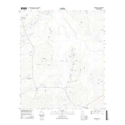
2014 Map of Gordonsville
USGS Topo · Published 2014About this map
Lowndes County's rural landscape is marked by small settlements and family-named cemeteries in this 2014 survey. The town of Mosses serves as a central hub, surrounded by a network of local roads such as Ash Creek Rd and Silver Creek Farms Rd. For genealogists, the map is a significant record of local burial sites, documenting Bogahoma Cem, Rudolph Hill Cem, and Miles Cem among others. The hydrology of the area is defined by managed water features and natural drainages, including Kellys Ditch, Russells Pond, and Bessie Beck Lake. To the south, the community of Beechwood sits near the junction of Al-21, while Gordonsville anchors the western side of the quadrangle. This detailed topographical study provides a clear view of how these interior Alabama communities were organized in the early 21st century, showing the proximity of residences to the small creeks and branches that drain the region.
Find a feature on this map
74 named features on this map. Tap any name to fly to it.
Don’t see what you’re looking for? This feature index may not catch every label — zoom into the map to look around manually.
Map Details
Editions of this 2014 Gordonsville Map
This is the sole edition of this map. No revisions or reprints were ever made.
Other maps of this area

1953 · Montgomery
USGS Topo · 1:250,000

1956 · Montgomery
USGS Topo · 1:250,000

1957 · Montgomery
USGS Topo · 1:250,000

1957 · Autaugaville
USGS Topo · 1:62,500

1957 · Benton
USGS Topo · 1:62,500

1957 · Braggs
USGS Topo · 1:62,500

1975 · Benton SE
USGS Topo · 1:24,000

1975 · Autaugaville SW
USGS Topo · 1:24,000

1975 · Autaugaville SE
USGS Topo · 1:24,000
1981 · Calhoun
USGS Topo · 1:24,000