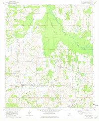
1981 Map of Gordonsville
USGS Topo · Published 1981About this map
Gordonsville and the surrounding Lowndes County countryside are defined by a network of rural churches and family burial grounds in this early 1980s snapshot. The landscape is dominated by the winding course of Big Swamp Creek and its tributaries, including Ash Creek and Buck Creek. Local community life centers around institutions like Central High Sch and several houses of worship, such as Mt Carmel Ch and St Paul Ch.
Find a feature on this map
28 named features on this map. Tap any name to fly to it.
Don’t see what you’re looking for? This feature index may not catch every label — zoom into the map to look around manually.
Map Details
Editions of this 1981 Gordonsville Map
This is the sole edition of this map. No revisions or reprints were ever made.
Other maps of this area

1953 · Montgomery
USGS Topo · 1:250,000

1956 · Montgomery
USGS Topo · 1:250,000

1957 · Montgomery
USGS Topo · 1:250,000

1957 · Autaugaville
USGS Topo · 1:62,500

1957 · Benton
USGS Topo · 1:62,500

1957 · Braggs
USGS Topo · 1:62,500

1975 · Benton SE
USGS Topo · 1:24,000

1975 · Autaugaville SW
USGS Topo · 1:24,000

1975 · Autaugaville SE
USGS Topo · 1:24,000
1981 · Calhoun
USGS Topo · 1:24,000