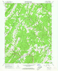
1965 Map of Gore
USGS Topo · Published 1967About this map
The Winchester and Western railroad winds through this mid-1960s landscape, following the contours of Back Creek and Mine Run past the settlement of Gore. The area is defined by sharp ridges like Timber Ridge and Bloomery Ridge, which separate the various hollows and runs. Local history is anchored by several small community centers, including Gainesboro, where the Gainesboro School and nearby Redland Church served rural residents. Near Whitacre, the historic Braddock Road crosses the terrain, a reminder of early transit routes through the Blue Ridge foothills. Other notable landmarks of this era include the Timber Ridge Airfield and the remote chapel at Mt Hebron Church, alongside several scattered family cemeteries that mark the longstanding agricultural ties of Frederick County and Hampshire County.
Find a feature on this map
49 named features on this map. Tap any name to fly to it.
Don’t see what you’re looking for? This feature index may not catch every label — zoom into the map to look around manually.
Map Details
Editions of this 1965 Gore Map
4 editions found
Other maps of this area

1894 · Winchester
USGS Topo · 1:125,000

1914 · Gerrardstown
USGS Topo · 1:48,000

1916 · Gerrardstown
USGS Topo · 1:62,500

1916 · Capon Bridge
USGS Topo · 1:62,500

1923 · Middletown
USGS Topo · 1:62,500

1923 · Capon Bridge
USGS Topo · 1:62,500

1937 · Capon Bridge
USGS Topo · 1:48,000

1937 · Gerrardstown
USGS Topo · 1:48,000

1937 · Middletown
USGS Topo · 1:48,000

1938 · Winchester
USGS Topo · 1:48,000