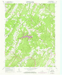
1965 Map of Gore
USGS Topo · Published 1973About this map
Winchester and Western rail lines and roads parallel the ridge-and-valley topography of this borderland between Virginia and West Virginia in the mid-1960s. The settlement at Gore sits at the southern end of Timber Ridge, while Gainesboro serves as a local hub to the east near Back Creek. Historically significant routes like Braddock Road intersect with modern developments such as the Timber Ridge Airfield. Local community life is grounded in several country churches, including Mt Hebron Ch and Redland Ch, along with the Gainesboro Sch. The landscape is dominated by steep summits like Bear Garden Mountain and Great North Mtn, with a network of narrow hollows and runs, such as Isaacs Creek and Mill Run, defining the habitable land between the ridges.
Find a feature on this map
53 named features on this map. Tap any name to fly to it.
Don’t see what you’re looking for? This feature index may not catch every label — zoom into the map to look around manually.
Map Details
Editions of this 1965 Gore Map
4 editions found
Other maps of this area

1894 · Winchester
USGS Topo · 1:125,000

1914 · Gerrardstown
USGS Topo · 1:48,000

1916 · Gerrardstown
USGS Topo · 1:62,500

1916 · Capon Bridge
USGS Topo · 1:62,500

1923 · Middletown
USGS Topo · 1:62,500

1923 · Capon Bridge
USGS Topo · 1:62,500

1937 · Capon Bridge
USGS Topo · 1:48,000

1937 · Gerrardstown
USGS Topo · 1:48,000

1937 · Middletown
USGS Topo · 1:48,000

1938 · Winchester
USGS Topo · 1:48,000