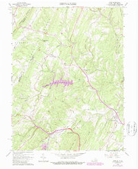
1965 Map of Gore
USGS Topo · Published 1987About this map
The Winchester and Western Railroad traces the valley floor near the West Virginia border, connecting the community of Gore with the wider region during this mid-1960s survey. The landscape is defined by parallel ridges including Timber Ridge and Bear Mountain, which hem in the drainage basins of Back Creek and Isaacs Creek. These watercourses provided the natural corridors for early settlement and infrastructure, as seen in the placement of the historic Braddock Road near Whitacre. Local life centers around small clusters of activity at Gainesboro, where the Gainesboro Sch and nearby Mt Hebron Ch served the rural population. Notable landmarks of the era include the Timber Ridge Airfield and the recreational waters of Holiday Lake, reflecting a mix of traditional agricultural land use and 20th-century development.
Find a feature on this map
47 named features on this map. Tap any name to fly to it.
Don’t see what you’re looking for? This feature index may not catch every label — zoom into the map to look around manually.
Map Details
Editions of this 1965 Gore Map
4 editions found
Other maps of this area

1894 · Winchester
USGS Topo · 1:125,000

1914 · Gerrardstown
USGS Topo · 1:48,000

1916 · Gerrardstown
USGS Topo · 1:62,500

1916 · Capon Bridge
USGS Topo · 1:62,500

1923 · Middletown
USGS Topo · 1:62,500

1923 · Capon Bridge
USGS Topo · 1:62,500

1937 · Capon Bridge
USGS Topo · 1:48,000

1937 · Gerrardstown
USGS Topo · 1:48,000

1937 · Middletown
USGS Topo · 1:48,000

1938 · Winchester
USGS Topo · 1:48,000