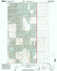
1997 Map of Gorham SE
USGS Topo · Published 2001About this map
The Little Missouri National Grassland dominates this landscape in Billings County, where the sprawling badlands terrain is defined by a network of ranching homesteads and energy development. Family-named outposts such as Eck Ranch, Banyai Ranch, and Abeluk Ranch are scattered across the section lines, connected by unimproved trails and four-wheel-drive tracks. Local education is centered at the Gorham Sch, a distinct landmark in the northeastern portion of the sheet near the Green River.
Find a feature on this map
15 named features on this map. Tap any name to fly to it.
Don’t see what you’re looking for? This feature index may not catch every label — zoom into the map to look around manually.
Map Details
Editions of this 1997 Gorham SE Map
This is the sole edition of this map. No revisions or reprints were ever made.
Other maps of this area

1953 · Dickinson
USGS Topo · 1:250,000

1953 · Watford City
USGS Topo · 1:250,000

1957 · Dickinson
USGS Topo · 1:250,000

1957 · Watford City
USGS Topo · 1:250,000

1962 · Fryburg NE
USGS Topo · 1:24,000

1962 · Fryburg NW
USGS Topo · 1:24,000

1962 · Belfield
USGS Topo · 1:24,000

1963 · Gorham SW
USGS Topo · 1:24,000

1963 · Gorham NW
USGS Topo · 1:24,000

1963 · Fairfield
USGS Topo · 1:24,000